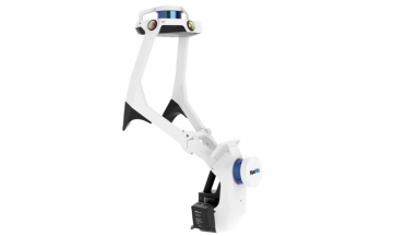


NavVis CLX is an agile, handheld reality capture device purpose-built for high-volume, everyday documentation workflows. It helps teams capture and deliver spatial data at scale when simplicity, reliability, and ROI matter.
Trusted, high-quality data
NavVis CLX produces clean point cloud data suitable for documentation, measurement, and downstream modeling workflows. Teams can work with dependable scan data while reducing cleanup effort.
Simple to learn, operate, and scale
NavVis CLX is fast to learn, easy to deploy, and built for repeatable workflows. Integrated 2D and 3D feedback helps teams onboard operators quickly and scale capture across more projects.
Built for the real world
Lightweight, ergonomic, and flexible, NavVis CLX supports reliable documentation in occupied or confined areas.
Reliable, complete data capture
Dual lidar architecture, live visualization of coverage (2D and 3D) help operators validate capture completeness while scanning.
Purpose-built
NavVis CLX is designed for rezpeatable, high-frequency documentation workflows such as area referencing, site assessment, quantity surveying support, and LOD200 scan-to-CAD/BIM.
No Videos uploaded for this product.