Wingtra drones: High-accuracy aerial mapping for UAE surveying projects
In a region defined by rapid urban development, complex infrastructure demands, and vast desert terrain, the need for precision in surveying has never been more vital. For engineering and surveying professionals across the UAE, Wingtra drones offer a game-changing solution. Distributed by Sigma Enterprises, Wingtra’s next-generation VTOL (Vertical Take-Off and Landing) drones are redefining what’s possible in aerial mapping, enabling faster, safer, and more accurate data collection across the most demanding projects.
Why drones are reshaping surveying in the UAEFrom megaprojects like highways, smart cities, and industrial zones to remote oil and gas installations, the UAE requires surveying technology that can keep pace with its ambitious vision. Traditional ground-based surveying methods can be time-consuming, labor-intensive, and limited by terrain access.This is where drones—especially those engineered for precision like the WingtraOne GEN II—become a powerful tool. They enable surveyors to cover large, challenging areas in less time, all while collecting ultra-accurate geospatial data. The result? Smarter decisions, reduced field time, and significantly lower operational risk.
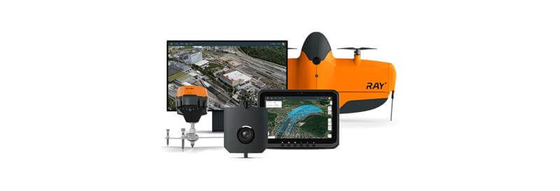
WingtraOne GEN II: Designed for high-performance mappingAt the heart of Sigma’s offering is the
WingtraOne GEN II, a fixed-wing VTOL drone that combines the flight efficiency of an airplane with the flexibility of a multicopter. This makes it ideal for UAE’s diverse landscape—from tight urban sites and rocky terrain to expansive desert zones.
Here’s how the WingtraOne GEN II stands out:
•
Oblique payload integration :The WingtraOne GEN II now supports oblique payloads for 3D mapping, delivering unmatched accuracy in modeling urban structures and complex surfaces.
•
PPK on every drone : Post-Processed Kinematic (PPK) technology ensures centimeter-level accuracy without relying on ground control points (GCPs), streamlining operations while reducing setup time.
•
42 MP camera and lower overlap requirements : The high-resolution camera and optimized flight path planning reduce image overlap, meaning fewer photos and faster processing—without compromising accuracy.
•
No terrain limitations : Its VTOL design allows the drone to take off and land in confined spaces or rugged environments, eliminating the need for large clearings or smooth runways. Delivering results for complex UAE surveying needs
The UAE’s infrastructure projects often demand rapid data collection over vast distances—whether it's surveying an industrial development in Abu Dhabi, assessing coastal zones in Ras Al Khaimah, or mapping construction progress in Dubai. Wingtra drones make these missions faster and more efficient to execute:
•
Faster turnaround : Surveyors can cover large areas in a fraction of the time compared to conventional methods, often completing aerial missions in just a few hours.
•
Reduced manpower and costs : With fewer ground control setups, less time in the field, and easy deployment, companies see a clear reduction in man-hours and resource allocation.
•
Enhanced safety : Teams spend less time in potentially hazardous or inaccessible areas. The drone collects data remotely, ensuring safety while achieving accuracy.
•
Multi-purpose functionality : Whether it's orthophotos for planning, 3D models for construction, or multispectral imaging for environmental assessment, WingtraOne is compatible with multiple payloads—offering flexibility in a single platform.
Seamless operation and dependable performanceEquipped with advanced fail-safe algorithms, self-diagnostic systems, and reliable electronics infrastructure, WingtraOne drones are built for dependable operation in real-world scenarios. The included rugged tablet and intuitive flight planning software ensure that even users with limited UAV experience can successfully complete missions from day one.
From setup to data capture to analysis, Wingtra’s ecosystem is designed for a smooth workflow, giving surveyors confidence in their tools—and more time to focus on insights.
Sigma Enterprises: Bringing global tech to local landscapesWith over 18 years of industry expertise,
Sigma Enterprises (www.sep.ae) serves as the UAE’s trusted partner in advanced technology solutions. By bringing cutting-edge products like Wingtra drones to the region, Sigma supports clients across industries—from civil infrastructure and oil & gas to education, defense, and environmental studies.
SIGMA is the only authorized distributor for Wingtra in the United Arab Emirates. SIGMA is also the authorized service provider for Wingtra in the region.
As part of its commitment to engineering excellence, Sigma not only provides the tools but also backs them with local technical support, training, and consultation. This ensures clients can maximize the potential of their drone investments from day one.
The future of surveying is in the air
As demand for accurate geospatial data grows, especially in high-value sectors like construction, utilities, and urban development, drone-based surveying is no longer just an alternative—it’s quickly becoming the standard. The WingtraOne GEN II, with its unparalleled accuracy, speed, and versatility, is at the forefront of this transformation in the UAE.
With Sigma Enterprises leading the charge in making this technology accessible and effective, surveyors and project managers across the region can now map smarter, faster, and safer—no matter how complex the challenge.
Explore the future of surveying with
Wingtra drones and Sigma Enterprises. To learn more or schedule a demo, visit
www.sep.ae.